Auckland’s magnificent harbour
Most majors cities are sited on either an excellent harbour or an easy river crossing. Auckland isn’t called the City of Sails for nothing – our harbour is one of the best in the world. And tsunamis only reinforce this.
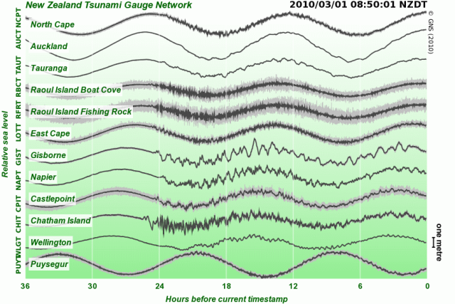
This picture shows a live snapshot from the Tsunami Gauge Network on the Geonet website. This snapshot was taken 24 hours after the first surges of the tsunami generated by the magnitute 8.8 quake in Chile yesterday. The Chathams and Gisborne both had surges greater than 1.5m at times, and many other bays and harbours on the east coast had 1m surges.
Auckland’s water level was barely ruffled by the tsunami. Coromandel, Great Barrier and the myriad other islands do a pretty good job of protecting it, not to mention the inner harbour is pretty well protected by the North Shore itself. Still, Ports of Auckland and the Navy took precautions. Even a small surge can do a lot of damage to a ship tied up to a port. PoA had all their ships out of the port by about 10am, with the surge expected at 10:50am. The car carrier and container ship headed out past Rangitoto, while the Dawn Princess cruise ship hung around in the inner harbour off North Head with dozens of other superyachts, the tugboats, Fullers ferries and smaller craft.
The Navy didn’t really get their ships out until about 11:30 or so. I didn’t see exactly when Te Kaha left, although I presume it left first, being the most expensive and being tied up at the most exposed berth. By 11:30am, Manawanui, Resolution and two of the four IPVs (Inshore Patrol Boats) were floating out in the harbour just in front of my place. Two of their IPVs stayed tied up for the entire afternoon. With Canterbury and Te Mana away, the Navy doesn’t seem to have the manpower to actually put it’s entire fleet to sea at once.
Pretty much everything was back in port by about 3pm, after it was clear that Auckland is so fantastically sheltered that the surge was only a matter of centimetres inside the harbour.
